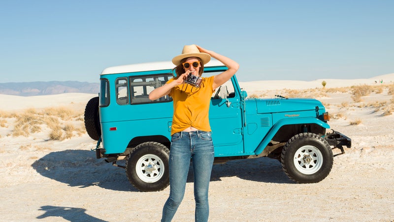
There’s real adventure out there. You just need to know where to look. We asked our editors and writers for their all-time favorite drives—and tips on how to pack as much riding, paddling, climbing, and running into them as possible.
Lake Superior Circumnavigation
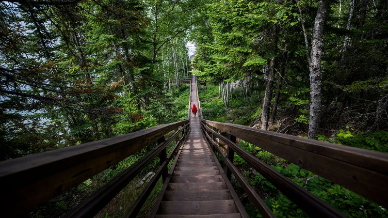
Miles: 1,300
Activities: Kayaking, wreck diving, mountain biking
Bring a bike, because there’s plenty of riding in hubs like Ontario’s Sleeping Giant Provincial Park and Copper Harbor, Michigan, as you circle the greatest of the Great Lakes. Begin your trip in Duluth, Minnesota, on the lake’s far southwestern corner, where hundreds of miles of flowy, technical, purpose-built singletrack parallels the 26-mile-long city and offers views of Superior. On the lake’s northwestern shore, Ontario’s Pukaskwa National Park receives fewer than 15,000 visitors annually, and even fewer attempt its challenging 37-mile Coastal Hiking Trail. Experienced divers can explore hundreds of shipwrecks preserved by Superior’s famously frigid water, including the Bermuda, a 150-foot schooner that sank in 1870 near Michigan’s Pictured Rocks National Lakeshore. Finish your epic seven-to-ten-day circuit by paddling Wisconsin’s Apostle Island National Lakeshore, a 21-isle archipelago just a few dozen miles east of where you started.
Pro Tip: Camp within a stone’s throw of the water at any of the dozens of state, provincial, and national parks that line the lake. —Stephanie Pearson
Great Basin National Park to Lake Tahoe, Nevada
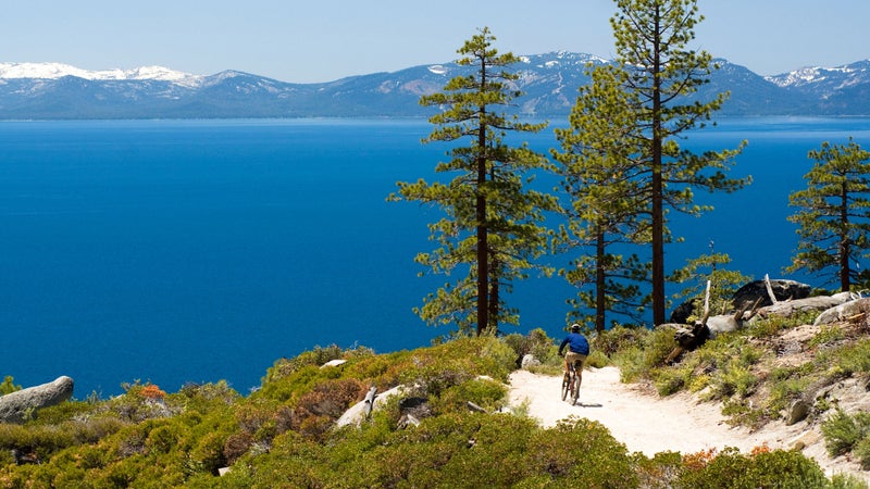
Miles: 400
Activities: Hiking, hot springs, petroglyphs
Despite its nickname, U.S. 50—the Loneliest Road in America—is never boring. Start in eastern Nevada at Great Basin National Park. (That way you can finish the trip with a well-earned dip in Lake Tahoe.) From its 4.6-mile round-trip Bristlecone-Glacier Trail, you can take in the park’s Wheeler Peak Glacier, one of the southernmost ice fields in the country. (It’s predicted to disappear in as little as 20 years.) Stop off in Ely, 66 miles west of the park, to play a few hands of blackjack at Hotel Nevada, a prohibition-era gambling hall that, at six stories, was once the state’s tallest building. From there it’s a 125-mile drive to the hiking, camping, and rock art at Hickison Petroglyph Recreation Area. The road-weary will enjoy a soak and the stunning views of the Toiyabe Range at Big Smoky Valley’s Spencer Hot Springs before making the final push for Carson City. Once you arrive at Lake Tahoe, detour from Highway 50 and take Highway 28 north to swim at Skunk Harbor, Whale Beach, or Secret Cove (if public nudity isn’t your thing, avoid the last one).
Pro Tip: Get gas whenever you see it, and pack plenty of water. —Ruben Kimmelman
Miami to Key West, Florida
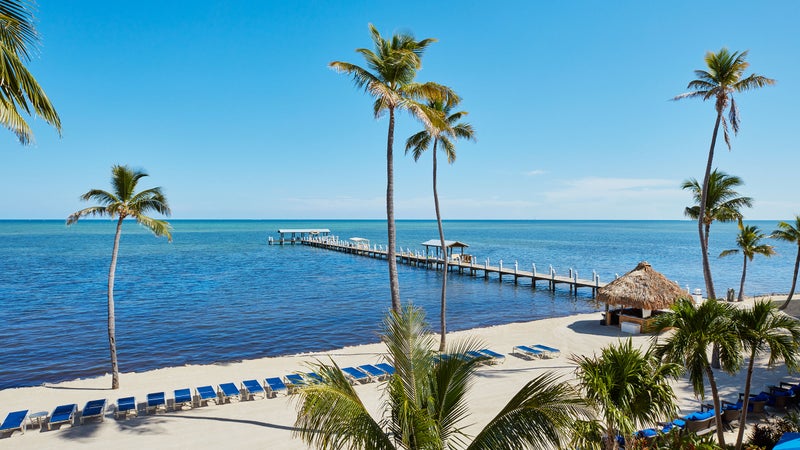
Miles: 171
Activities: Saltwater fly-fishing, reef diving, conch fritters
The drive from Miami International Airport to Key West makes for a bona fide tropical road trip, with dozens of state parks, wildlife sanctuaries, and plenty of roadside seafood shacks. Get out of the city fast, stopping only to load up on conch fritters at Alabama Jacks on County Road 905A. Once you cross the sound to North Key Largo, hike under the sea grape trees and mahogany mistletoes of Dagny Johnson Key Largo Hammock Botanical State Park. After switching over to famed Route 1, snorkel among the angelfish at John Pennekamp Coral Reef State Park and dive to a Spanish shipwreck at Cannon Beach. Cheeca Lodge, in the village of Islamorada, has bounced back from 2017’s Hurricane Irma with $25 million in restorations and renovations, and it’s still one of the region’s best base camps from which to prowl the backwater flats for snook, bonefish, and tarpon. Once you’ve caught your limit, it’s on to Key West and mile marker zero. Connect with the folks at Southernmost Sailing School, who can show you your bowline from your clove hitch and take you out to see the dolphins.
Pro Tip: US-1 Radio gives you traffic, island news, and lots of classic rock. —Tim Neville
Bentonville to Mount Magazine State Park, Arkansas
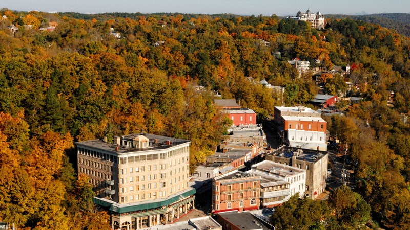
Miles: 211
Activities: Paddling, climbing, leaf peeping
Pack a trail bike, a canoe, and a pair of hiking shoes for this tour of America’s most overlooked mountain range: the Ozarks. Start by exploring Bentonville, home to Walmart, the world-class Crystal Bridges Museum of American Art, and hundreds of miles of the best mountain biking between the Appalachians and the Rockies. From there, it’s just an hour drive east on U.S. 62 to funky Eureka Springs for a dose of classic Victorian structures, hip art galleries, and the Thorncrown Chapel, an architectural gem of soaring glass and timber set in the surrounding woodland. Veer south to Scenic Byway 7 and head for the Buffalo National River to float easy rapids below its 500-foot-tall limestone bluffs. Climbers should make a detour to nearby Horseshoe Canyon, a dude ranch with over 400 established routes and the site of the 24 Hours of Horseshoe Hell climbing competition, held every autumn. After crossing the Arkansas River, it’s a short jaunt east to the Ouachita Mountains and hang gliding, backpacking, and camping at Mount Magazine State Park.
Pro Tip: The park lodge sits atop the state’s highest point (from $218). —Nicholas Hunt
Carlsbad, New Mexico, to Buena Vista, Colorado
Miles: 635
Activities: Sand sledding, peak bagging, summer skiing
Skip the overcrowded Carlsbad Caverns National Park in favor of New Mexico’s rugged Brokeoff Mountains Wilderness Study Area, which has remote trails that wind through cacti, agaves, and soaptree yuccas. Then it’s 140 miles north through Lincoln National Forest to the gypsum dunes of White Sands National Monument. It’s too hot in summer to camp, but there are six miles of trail for trekking and plenty of sand for sledding. Join up with U.S. 285, your route for the rest of the journey, and head north to Santa Fe and the ample hiking and biking in the foothills of the Sangre de Cristo Range. End the day with a soak at Ten Thousand Waves spa, a southwestern take on a classic Japanese onsen. Continuing north, be sure to climb the gentle volcanic slopes of San Antonio Mountain immediately off the highway on the New Mexico side of the state border, then hit up Calvillo’s restaurant in Alamosa, 50 miles farther north, for amazing Colorado-style huevos. Outside Salida, click into your backcountry skis for a late-season skin up Monarch Ski Area, or ride the 36-mile Monarch Crest Trail for some of the best singletrack in the country. Then just 25 miles north of Salida, you’ll find the small town of Buena Vista, a prime location for bagging fourteeners and kayaking the Arkansas River. Stop by Brown Dog Coffee for a strong brew: you’ll need it to get up Colorado’s highest peak, nearby 14,440-foot Mount Elbert.
Pro Tip: Don’t miss the homemade malted milk balls at New Mexico’s retro Clines Corners truck stop. —Axie Navas
Great Smoky Mountains National Park to Boone, North Carolina
Miles: 193
Activities: Paddleboarding, trekking, boiled peanuts
It would take two weeks to do justice to the Blue Ridge Parkway, a 469-mile, two-lane byway with endless Appalachian views and easy access to some of the South’s best adventures, but you can knock out its stunning North Carolina section in a handful of days. First up? Trekking to LeConte Lodge, a hike-to backcountry inn that sits at 6,400 feet in the heart of Great Smoky Mountains National Park. Be sure to stop and enjoy the 80-foot cascades along the Rainbow Falls Trail as you head out. From there, follow the parkway into Asheville to paddleboard or fly-fish the mellow French Broad River before sipping a few pints at some of the city’s 30 craft breweries. If you have the legs, the region is home to some of the best singletrack in the East, like the jump-heavy Green’s Lick Trail in the Bent Creek Experimental Forest. From town, head north past 6,684-foot Mount Mitchell—the tallest peak east of the Mississippi—to the Roan Highlands, where the Appalachian Trail crosses a series of treeless peaks covered with native grasses. Knock out the 5.5-mile hike along the trail to the Overmountain Shelter, an old barn with a sleeping loft that’s a favorite of through-hikers.
Pro Tip: Look for roadside stands selling boiled peanuts, a southern delicacy, on the country roads just off the Blue Ridge Parkway. —Graham Averill
Quebec City to Saguenay Fjord and Back
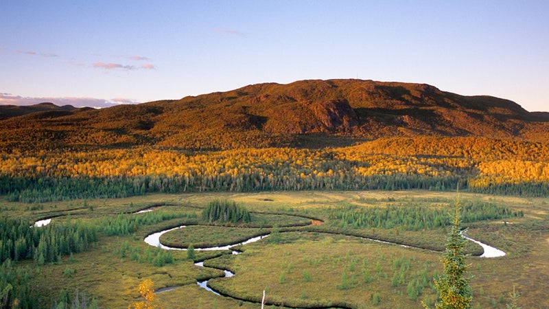
Miles: 448
Activities: Tubing, via ferratas, cycle touring
With its hilltop châteaus and charming old-world-style streets, Quebec City is a worthy road trip, but it’s even better as a jumping-off point for a 450-mile lollipop-shaped route through the province’s intense glacial-carved topography. Head north on Quebec 175 to Saguenay, population 145,949, stopping along the way to rent a tube and float among the hardwoods lining the calmer sections of the Jacques-Cartier River that cuts through 260-square-mile Jacques-Cartier National Park. Then it’s on to the showstopper—the road-and-ferry loop known as the Route du Fjord, a 187-mile lap around the beluga whale-filled waters and 1,000-foot-high granite walls of Saguenay Fjord. Three via ferratas race along the cliffs in the 123-square-mile Saguenay Fjords National Park, including La Grande Dalle, a 656-foot-high ramble across a gigantic vertical slab. Before heading back to Quebec City, stop at the Parc Aventures Cap Jaseux campground, on the fjord’s northern bank, to cast for Atlantic salmon, and spend the night in the camp’s 20-foot-diameter glass dome tucked among the pines high over the water (from $198).
Pro Tip: The Route du Fjord makes for a spectacular bike tour, too. —T.N.
Fayetteville to Snowshoe, West Virginia
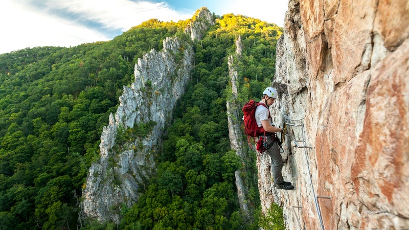
Miles: 256
Activities: Rafting, climbing, bluegrass
West Virginia has some of the wildest terrain in the mid-Atlantic, and this 256-mile trek takes it all in. Start in the paddling haven of Fayetteville, a mile away from the New River Gorge. Rafting season on the Class II–V New River runs from early spring through fall, but the best whitewater can be found in autumn on the Gauley River, one of the toughest commercially rafted waterways in the country. North of Fayetteville, Dolly Sods Wilderness Area is full of red spruce, cold creeks, and massive views of the Allegheny Mountains. Grab a pint at Mountain State Brewing and a room at the Cooper House in Thomas, which has complimentary afternoon libations. Drive south and sign up for a two-day trad-climbing course with Seneca Rocks Climbing School, or tackle the multi-pitch routes that rise several hundred feet from the valley floor on distinctive rock fins on your own. Cap off the journey at Snowshoe Mountain Resort’s lift-served bike park, which will host a World Cup Downhill race this summer.
Pro Tip: The Purple Fiddle, in the town of Thomas, attracts some of the best touring bluegrass musicians in the country. —G.A.
Glacier National Park, Montana, to Jackson, Wyoming
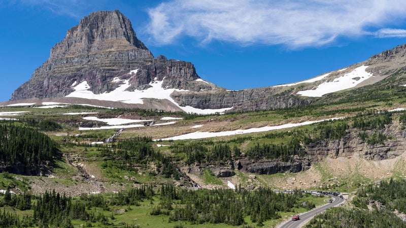
Miles: 476
Activities: Car camping, day hiking, hot springs
Sometimes called the National Parks Highway, U.S. 89 runs due south from the Canadian border to Flagstaff, Arizona. But if you’ve only got a week, start at the icy peaks of northern Montana and end at the boiling waters and mountains of Yellowstone and Grand Teton National Parks. The trailhead for the 11.8-mile Highline Trail—which will treat you to alpine meadows and views of the Livingston Range—is just off Going-to-the-Sun Road in Glacier. Buffalo Joe’s Eatery and Saloon, in Dupuyer, has amazing burgers and a friendly eight-room motel around back. Wake up and hike the Watchable Wildlife Trail at the nearby Theodore Roosevelt Memorial Ranch, where there’s a good chance you’ll spot elk and golden eagles. After that, you can fish for big browns on the Missouri River. The town of White Sulphur Springs is your midway point. Make a pit stop at its hot springs, or plan your trip for July’s rootsy Red Ants Pants Music Festival. From there, it’s on to Yellowstone and the Tetons, both of which need no introduction.
Pro Tip: Join a guided dinosaur dig at the Two Medicine Dinosaur Center in Bynum, Montana. —Charlie Ebbers
Fernie to Revelstoke, British Columbia
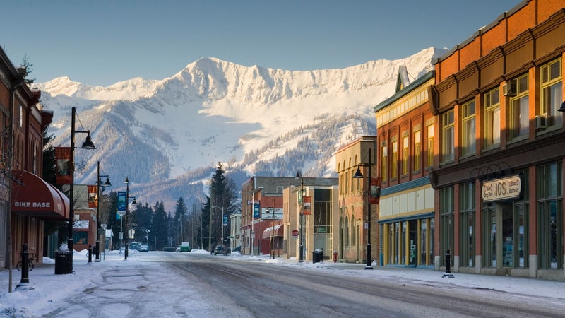
Miles: 378
Activities: Mountain biking, craft beer, small towns
Let the hordes have western British Columbia—the Kootenay Rockies in the east are loaded with hundreds of miles of new, empty singletrack, lift-served bike parks, and hip, blue-collar mountain towns. Kick off the trip in Fernie, in far southeastern B.C., and earn a free beer and a medal from Fernie Brewing by completing the Trail to Ale Challenge, where you’ll attempt to bag three of Fernie’s toughest peaks by foot or bike in just 24 hours. Then head northwest to Bootleg Mountain, outside Kimberley, where a handful of downhill trails like Atlas Shrugged and NIMBY offer up to 2,000 feet of descent. From there, it’s on to Panorama Mountain Resort, one of the best bike parks east of Whistler, Radium Hot Springs, at least 124 miles of cross-country trails overlooking Golden, and the high-alpine biking in Revelstoke, where its namesake resort will open its first gondola-served trail this summer. Finish up by heading south on B.C. Highway 23 toward Naksup and use your all-wheel-drive vehicle and sturdy hiking boots to reach the rugged Halfway River hot springs, a 40-minute drive north of town.
Pro Tip: Kimberley Centex Market looks like a gas station (and it is), but it also has the best coffee and cold-pressed juice in the province. —G.A.
Theodore Roosevelt National Park, North Dakota, to Badlands National Park, South Dakota
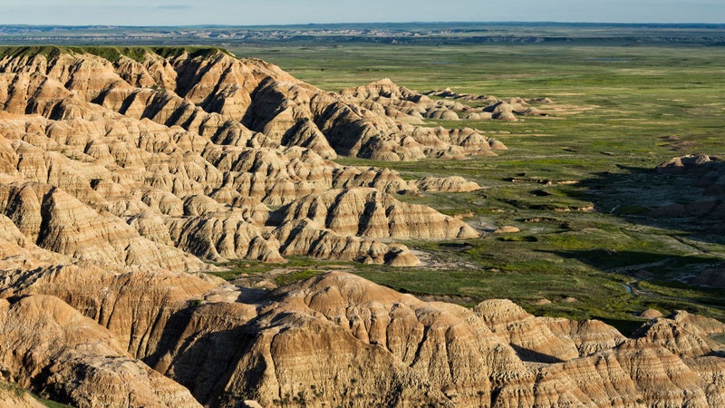
Miles: 550
Activities: Fly-fishing, wildlife, history
If you think the Dakotas are only for flying over, you’re dead wrong. This 550-mile meandering drive winds from the grasslands and canyons of North Dakota’s Theodore Roosevelt National Park to the state’s southern twin and the buttes and spires of Badlands National Park. Start by mountain biking the Maah Daah Hey Trail, 144 miles of rugged singletrack, river crossings, and precipitous ridge climbs just outside South Billings. Across the border, Custer State Park has herds of bison, and rainbow trout lurk in nearby Spearfish Creek, a cold-water fishery just off the road in the Black Hills. Take a break from the sun and explore a few of the 147-plus miles of mapped caverns in Wind Cave National Park, before ending your journey at the 60-foot-tall mugs of Washington, Jefferson, Lincoln, and Roosevelt at Mount Rushmore.
Pro Tip: Got kids? Stay the night in a brand-new, impressively plush covered wagon at the Wagons at Rushmore Shadows, which includes a cowboy hot-dog dinner served around a fire (from $154). —S.P.